
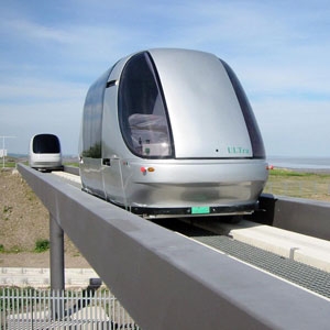
Pod Cars are automated driverless vehicles that will operate on traditional roadways creating personal rapid transit systems”
* use contributes to carbon monoxide, nitrogen oxides, and hydrocarbon emissions
* are expensive and if not shared typically are parked for most of there lifetime
* uses of cars are for 1-2 people transports
* have the technical capability to have small, energy efficient cars
* some cases cars with automated drivers are safer than humans
* automated shared car system would reduce emissions, decrease grid lock in cities, increase safety, enable faster personalized public transit options, and better utilize vehicles
What is your one big idea for cities in 2012? Submit a blog post to info@theurbanvision.com along with a bio & Pic.
Tag Archives: Transit

Despite a great public transit network and bicycling/pedestrian …
Despite a great public transit network and bicycling/pedestrian infrastructure, a majority of residents in Portland still choose single-occupancy car trips as their primary mode of transport. The two primary reasons for such travel behaviour are thought to be lack of information amongst road users about other modes of transport, and habit that favours car use. So with the goal of reducing vehicle miles travelled (VMT), City of Portland decided to try something different, inspired by the TravelSmart Australia Programme.
Hence, in 2002-03, City of Portland engaged individualised marketing expert SocialData to implement the Multnomah/Hillsdale TravelSmart pilot project, making it the first ever large-scale individualised marketing project in the US. The concept of individualised marketing involves providing customized information about alternate travel modes including walking, biking, transit and carpooling to individuals identified as willing to try out other modes of travel (see interview with Derek Hofbuaer). The information (delivered by bicycle 98 per cent of the times) coupled with continuous telephone contact motivates individuals to start thinking about other modes of travel as well as helps them get started.
Pilot project – TravelSmart
The pilot project, implemented with support from the Oregon Department of Transportation, Trimet and Metro, covered 600 households (approximately 1,200 individuals) and was deemed successful. Encouraged by initial successes, City of Portland decided to combine TravelSmart with the launch of the new Interstate MAX light-rail line in 2004.
The Interstate TravelSmart project covered over 14,000 people in north and northeast Portland. Prior to the marketing project, a before-survey was conducted with a randomly selected sample of 1,460 persons in the target area to determine the current household travel behaviour in the area. In addition, a control group was surveyed that did not receive any marketing materials. During September-October 2004, 6,281 households (14,446 people) were contacted for brief telephonic interviews for providing information, with a 92 per cent response rate.
A year after the before-survey was conducted, another random after-survey covering 1,708 people was conducted to measure changes in travel behaviour due to individualised marketing with the control group as the baseline reference. An in-depth study followed this project, under which selected households were interviewed in detail about their modal choices. All data was analysed to assess the viability of promoting alternative modes to cars.
Figure 1 provides a snapshot of the Interstate TravelSmart project.

The results from the post-implementation analysis indicated that car trips had decreased in the target area and shifted to walking, biking and public transit. The total reduction in VMT was 6.8 million miles (14 per cent). It was also indicated that the trips within the community increased after the individualised marketing campaign, which indicates possible community business benefits. In addition, the combination of light rail and TravelSmart increased physical activity 25 hours each year (or about 2 hours each month).
Further, specific value addition of individualised marketing campaigns was demonstrated by comparisons with the control group. Post the opening of the Interstate MAX Line, transit ridership increased for the control group by 24 per cent as compared to a 44 per cent increase in the target area. The reductions in car trips and VMT were also greater for the target area, with 9 per cent more reductions in car trips and 8 per cent more reductions in VMT.
City-wide implementation – SmartTrips
Following the completion of its TravelSmart programme in collaboration with Socialdata in 2004, the Travel Options department of the Portland Bureau of Transportation (City of Portland) modified the programme to reduce costs, add hands-on experiential activities, and extend the contact period with residents to eight months a year. Thus was launched Portland SmartTrips, a large-scale recurring individualised marketing project for the city. The basic objective was to ensure that everyone who lives, works or runs a business in the city knew about all the travel options available to them. Hence, the SmartTrips programme was launched in 2005 in a phased manner, starting with the Eastside Hub target area.

Pilot project -Eastside Hub
The programme has a dual approach whereby residential areas are targeted with individualised marketing tools such as free bike/walk maps and information resources while partnerships are forged with businesses to offer employee incentives that encourage decreasing dependence on drive-alone car trips.

Using an interactive and fun method, adequate support was provided to area residents (in the form of customized information) to make new travel choices a part of their daily life. A variety of useful materials were provided such as a Southeast Portland walking map, a schedule of strolls for seniors, customized transit route information, and walking/biking kits.
Programme rollout
Since then, the programme has reached out to all neighbourhoods in a phased manner, targeting one neighbourhood each year between late-March (weeks before the good spring/summer weather kicks in) and early-November. Selection of the target area each year is based on a multitude of favourable factors such as land-use patterns, transit services availability, bike and walking infrastructure, and new light rail or bicycle and pedestrian trails. Table 1 indicates the annual rollout of the SmartTrips programme since the pilot project was completed for the Eastside Hub area in 2005.
| Year | Targeted area |
| 2006 | Northeast Hub |
| 2007 | Southeast |
| 2008 | Southwest |
| 2009 | North-Northwest |
| 2010 | MAX Green Line |
| 2011 | North-Northeast |
Source: Portland Bureau of Transportation
In general, a SmartTrips rollout in a targeted area involves sending each household in the area a newsletter in late-March showing a calendar of nearby walks, bike clinics and Portland By Cycle rides. Other transportation projects such as area streetscaping, Safe Routes to School projects and transit services are also included. Most importantly, the initial newsletter has a notice for residents informing them about the SmartTrips order form that residents may use to ‘order’ information and incentives for alternative transportation.
Order forms are then sent out in batches covering about 2,500 households per week. Majority of deliveries are completed on bikes. The orders are delivered in vinyl tote bags, and are accompanied with a SmartTrips Calendar of events, an area walking map and a thank you letter.
Orders are typically processed and delivered within a week of receiving the order. It is believed that the programme’s success critically depends on the speed and efficiency of delivering materials ordered, because late deliveries may fail to cash in on the moments when a household is motivated to consider other modes (which is when they place orders). Clearly, the programme relies on striking when the iron is hot.
To ensure complete outreach, households that do not reply with a filled-out order form three weeks after receiving it are sent postcard reminders. With each order, one incentive can also be chosen. I myself have been able to use many of these incentives such as the blinking lights for my bike and the free neighbourhood maps to enhance my biking experience in the city. Other incentives available are a SmartTrips umbrella, Bicycle Map Bandana and Transportation Options T-shirt.


A second newsletter is circulated in May containing a web address and phone number, reminding residents to order materials, in addition to a list of more events and activities. The remaining three newsletters – one on July 1, another on September 1 and the final one in mid-November – are circulated to anyone who orders materials or attends any one event.

Suite of events
The suite of events/programmes used to encourage walking, biking and transit is broadly the same each year, inclusive of the Ten Toe Express Walking Campaign, Portland By Cycle Campaign, Senior Strolls, and Women on Bikes.
- Ten Toe Express Walks – Around 4-6 guided walks are organized every month from May through September to encourage people to explore routes on foot and make walking buddies.

- Senior Strolls – Guided walks are offered from May to October under this banner, aimed particularly at seniors to help them become active and comfortable with walking as a transportation option. This is especially useful since often the ageing community feels most disconnected and requires options to get around and lead an active lifestyle. These slower paced strolls start and end on public transit routes.

- Portland By Cycle Rides and Classes – This is a series of evening rides and classes offered from May up to September. The rides are designed for new cyclists as well as people who have not ridden a bike in years. A safety briefing opens the ride program, and safety tips are offered along the ride by trained volunteer and staff ride leaders. Eight free classes are offered covering varied topics ranging from shopping by bicycle, introduction to bike commuting, to bicycle touring, riding in the rain and basic bike maintenance.

- Women on Bikes – This series is targeted particularly at women, since research suggests that the average bicyclist is a young white male and male bicyclists outnumber female bicyclists. The series includes bike clinics, conversations and rides covering topics such as bike selection, gear for bike and cyclist, bike handling skills, basic bike maintenance, the city’s bikeway network, cyclists’ rights and responsibilities, how to ride with children, how to shop by bike, and bike advocacy. Rides are scheduled to practice skills, try different routes, meet other women to ride with, and demonstrate the ease of commuting by bike.

SmartTrips Business and Welcome
In addition to the residential track, City of Portland is also offering two parallel programmes to increase impact. These are the SmartTrips Business, targeted at employers; and Welcome SmartTrips for residents who recently moved into a new area. The Welcome SmartTrips is a pilot project and is available only for limited zipcodes for now. To eligible households, a goodie bag containing maps and guidebooks, as well as a choice between a chocolate bar from Portland’s Moonstruck Chocolate or an All Day TriMet ticket, is delivered on bike.


Photo of the goodie bag courtesy of Paul Smith (@GreenSmith on Twitter).
In addition, to reach out to diverse communities, Portland Bureau of Transportation recently came out with bike maps in five new languages (Burmese, Nepali, Somali, Russian and Arabic), for immigrants whose first language is not English. The maps are already available in English and Spanish.
Results
The individualised marketing projects run by City of Portland have succeeded in reducing drive-alone car trips by 8-12 per cent every year (2004-11), with a simultaneous increase in the use of walking, biking and public transit as well as carpooling. This is evident in the current modal split. In 2008, this change in modal behaviour was estimated to result in reduction in carbon dioxide emissions amounting to 19 million pounds. Using this as an average, this would imply a reduction of over 110 million pounds of carbon dioxide emissions during 2005-10. A particularly significant reduction in drive-alone trips was recorded with the completion of the SmartTrips Green Line (2009) with the final report showing a decrease in drive-alone trips by 18.4 per cent in the target area, helping to save 48 million VMT in the area.
These impressive results have been confirmed through random telephone surveys as well as trip diaries recorded post-marketing. The participation rate (indicated by percentage of area residents that either ordered materials or participated in an activity) for all areas was an average of 30 per cent (similar to the modal share for alternate transportation). Each walk is attended by 30-50 particpants (with new people joining in each time), and each bike ride is attended by about 18 cyclists. The programme is also popular with area residents who submit an average of 1,000 comments annually in praise of the programme.
In addition, bike-friendliness through the availability of information and institutional support under the SmartTrips programme has been a key determinant in the choice made by many to move to Portland (over a third of recently moved respondents in a survey). Businesses have also come out in support of the programme, claiming that biking and walking helps them market their business better.
Comparing these benefits to the cost of the programme allows greater appreciation for the cost-effectiveness of the programme given such impressive results. A typical 20,000-household programme costs $570,000, which translates into $10 per person in any SmartTrips area.
Hence, Portland’s individualised marketing programme has been and continues to be quite impactful in encouraging people to choose sustainable modes of transport. With a large number of captive users of biking and walking and public transport in India, a similar programme would be extremely beneficial in ensuring that the captive users continue to remain choice users even when motorized personal transportation modes such as personal cars and motor bikes become affordable to them.
Useful links
http://www.walkinginfo.org/library/details.cfm?id=3961
http://www.c40cities.org/docs/casestudies/transport/Portland%20-%20SmartTrips.pdf
http://www.portlandonline.com/transportation/index.cfm?a=142341&c=39300
http://www.portlandonline.com/transportation/index.cfm?c=46030&a=220818
http://www.portlandonline.com/transportation/index.cfm?c=52160&a=331242
http://bikeportland.org/2007/04/23/pdots-new-bike-map-bandanna-3463
http://bikeportland.org/2008/02/12/smarttrips-leads-to-less-car-trips-in-southeast-6678
http://bikeportland.org/2010/12/28/pbots-smarttrips-program-results-in-fewer-drive-alone-trips-in-east-portland-45043
http://www.portlandonline.com/transportation/index.cfm?c=46030&
Mumbai and Delhi aren’t the only places with …
Mumbai and Delhi aren’t the only places with transit headaches. In fact, the mother of all freeway cities, Los Angeles, has reached its breaking point. Just try taking the 10 freeway eastbound any day after 4 p.m. I dare you. The effects of traffic and pollution from this problem could soon cripple the city permanently.
But there are signs of hope. First is the recent passage of LA County Ballot Measure R, which will give the city up to $40 billion in transportation funding over the next 30 years. Second is President Barack Obama’s efforts to make the largest investment in U.S. infrastructure since the 1950’s.
But all this money will mean little if we spend it the same way that we have in the past. We need to think big; to break the outmoded boundaries between transit and its surroundings; between design and infrastructure; and between the professions of architecture, engineering, and planning. We need to reinforce and improve successful new thinking like transit oriented design, light rail, zip cars, biofuels, and other new technologies and systems.
In order to help this process along my publication, The Architect’s Newspaper (www.archpaper.com), has teamed with the Southern California Institute of Architecture (SCI-Arc) to launch a competition promoting creative ideas for LA’s transit system. The contest, called A New Infrastructure: Innovative Transit Solutions For Los Angeles, is open for entries, which are due by March 13. (Participants can find information and an entry form at http://www.sciarc.edu/news.php?id=1376) Winners will be announced on March 21.
The contest is designed to encourage solutions outside the normal parameters of LA’s—and the country’s—existing transportation-related solutions. We hope entrants—including architects, engineers, planners, or (hopefully) a combination of the three— will explore new transit systems and technologies, new transit-related buildings and neighborhoods, and a new thinking about the relationship between transit, architecture, open space, and urban redevelopment. Competitors will be asked to focus on specific rail extension projects and also take a look at larger-scale, inter-related transit planning challenges. Interested entrants should check out
Fifty years ago our new highways increased our cities’ mobility and its efficiency. But they subsequently destroyed neighborhoods and have in recent years ceased to be able to handle voluminous traffic. Meanwhile mass transit systems continue to age, while L.A.’s remains stalled with a limited ridership and a limited reach. Sure there are subways, and our bus system is certainly extensive, but very few here take mass transit.
Some have predicted that the age of the automobile will soon end. I’m not one of them. People will always relish the opportunity to set out on their own, and cars will continue to become more efficient and ecologically sound. But cars cannot sustain us. We need new transit systems to supplement them, and to insure that our city doesn’t grind to a halt. These systems need to be designed to encourage riders to take and enjoy them, and in ways that nourish and improve our neighborhoods and open up new opportunities; be that for open space in the city, for cultural facilities, or anything else we can’t think of.
Hopefully these ideas will encourage our transit planners, city planners, and civic leaders, some who will have a seat on our jury, to be inspired and to think fresher. Maybe a plan will become reality, maybe it won’t, but we hope this competition will draw attention to an issue that could make or break the prototypical freeway city. If no one is paying attention we will get more of the same. Or nothing at all. Already the Los Angeles Metropolitan Transportation Authority has announced in a report that because of budget shortfalls the much-hyped “Subway to the Sea” stretching from Downtown LA to Santa Monica, would be stalled until 2032. LA Mayor Antonio Villaraigosa has sharply criticized these dates, and we must too. If we are active in this process, imagining schemes and pressuring our government to move swiftly and innovatively, there’s no telling what we can accomplish.
