
As an urban planner with conscious heart toward sustainability I always try to find its core idea that leads to the path towards sustainable development. Is it the need of the hour due to environment degradation? Is it the recent fad? what makes our fraternity more conscious about this thing?
As a planner I tried to find answers to my above stated queries and it further led me to explore my beliefs and religion that I practice. As I read more on this aspect I began to realize that Hinduism is not a religion but its a way of life that one should lead in his/her lifetime. In this world there could be millions of material manifestations and forms, but the sustaining force for all is not material but spiritual. Everything has life, so all the life is reverent and has to be protected, upheld and sustained. Respect for the environment is the part of Hinduism where earth is our mother, the mountains are abodes of gods, trees are sacred, rivers are holy, and the animals are vehicles of the Gods, and above all, man’s sustenance has to be ecological.
Hinduism also talks about the essence of vegetarianism: eco-consciousness. There is no absolute truth in Hinduism, truth is relative, and so is our diet. The consumption of animal flesh itself is not non-vegetarian. If an Eskimo killed an animal and ate its meat to survive, or in the desert one kills someone for its flesh, he is still vegetarian. This is because, in the food chain, one consumes the least life form for one’s survival. But in case of tropical India, where there is plenty of vegetation, kill only vegetable, because it has a lesser life quantum than an animal. One doesn’t need to consume more than necessary; there is enough for everyone’s need.
Thus, sustainability can be defined from spirituality and Hinduism which is essentially a dialogue of values that defies consensual definition. This aspect is the strength of India and I am sure that this path will reveal a permanent path to sustainability to all architects and urban planners.

 photo credit: Arun Katiyar
Category Archives: Others
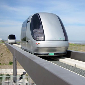
Pod Cars are automated driverless vehicles that will …
Pod Cars are automated driverless vehicles that will operate on traditional roadways creating personal rapid transit systems”
* use contributes to carbon monoxide, nitrogen oxides, and hydrocarbon emissions
* are expensive and if not shared typically are parked for most of there lifetime
* uses of cars are for 1-2 people transports
* have the technical capability to have small, energy efficient cars
* some cases cars with automated drivers are safer than humans
* automated shared car system would reduce emissions, decrease grid lock in cities, increase safety, enable faster personalized public transit options, and better utilize vehicles
What is your one big idea for cities in 2012? Submit a blog post to info@theurbanvision.com along with a bio & Pic.
I have three ideas: . 1. Social impact …
I have three ideas:
.
1. Social impact bonds. Leveraging public dollars with private / nonprofit innovation and accountability.
.
2. Outcomes-based permitting. Offering greater flexibility in urban design in order to stimulate private investment.
.
3. Reclamation of government owned land for public space. Using vacant space (e.g., alleyways, utility corridors, overhead and underground railways) as parks, open space, public gardens, etc.
.
What is your one big idea for cities in 2012? Submit a blog post to info@theurbanvision.com along with a bio & Pic.

photo credit: OiMax
Having been associated with the real estate industry …

Having been associated with the real estate industry earlier on in my career, I had to deal with immense level of corruption first hand. I had to see that bribes needed to be paid at various levels to get approvals at every stage of the building process. I believe that the criminalization and corruption in India’s real estate was due to a systemic failure. The toxic License Raj might have vanished from some sectors of the Indian economy but it is well and truly alive in the Indian real estate. From buying land to getting building completion certificates, the lengths that the real estate industry has to endure to complete a project is outrageous. Mumbai, for example, has a multi-stage building approval system and requires over 50 certificates before completion of a project, which can take anywhere from 24 months to 36 months. This level of red tape, along with regulations that are vague, allows politicians or bureaucrats to use their discretionary powers (read corruption). There is a desperate need to fix our rule of law & governance systems and make them more transparent and simple. It’s a crucial issue that is at the heart of ensuring good governance in multiple sectors especially in the area of urbanization that’s at the heart of our work at The Urban Vision.
So even as I have been an ardent supporter of the Anticorruption Movement in India as a wonderful step in the right direction, I am going to raise a few points that are concerning.
- Looking at the tone of the anticorruption debate in India. I think that we are taking our Democracy for granted. My Favorite Professor Francis Fukuyama points out the “anti-statist political culture” in this recent CNN interview and says “We don’t appreciate the importance of having a functioning government and how difficult it was historically to create a society in which government existed” . See : http://globalpublicsquare.blogs.cnn.com/2011/08/19/fukuyama-americans-take-government-for-granted/ . State is important too. Let’s not lose sight of that Idea.
- Let’s stop undermining our democracy. You cannot hold one of the key institutions of our democracy “the Parliament” to gun point and tell them to pass “the Civil Society’s” bill (I am not an expert in this area, But even to me , the bill looks way too nascent at this time. It looks more like a populist rhetoric rather than a substantive law at this moment). See : http://www.indiaagainstcorruption.org/salient.html . The bill needs time. We will need to carefully examine all components of it and ensure enough checks & balances. We desperately need the experts to examine & make suggestions and take note of how such committees have failed or succeeded in other parts of the world. The Devil is in the details.
- It’s naïve to assume that an anticorruption bill will solve all our problems. It’s a step in the right direction no doubt. But an all-powerful anticorruption committee can be a threat to democracy too. We have seen that Anti-Corruption Committee’s, if too powerful and without accountability can abuse power as well. Case in Point, Indonesia: http://www.thejakartaglobe.com/commentary/do-we-still-trust-the-kpk/458006 . Individuals in anti-Corruption Committee’s can be as susceptible as anyone else to corrupt practices. It’s a tough Balance. It’s needed, but the details are more important than the generic ideas. Or we will be creating another monster.
- We must be strategic in building these institutions. Have a look at Jan LokPal Charter http://www.indiaagainstcorruption.org/salient.html . Jan LokPal charter is basically corruption at every level of Public life (It’s like another court system. We are already aware of how inefficient our legal systems are because of the way it was structured.) We are again trying to build another institution whose charter is everything. So in the end of it, it won’t solve anything. Justice delayed is justice denied.
I don’t have answers to some of these burning questions. In fact, I am not very clear of my own position on these issues at this time. But I would love to see some sense of civility & balance in these debates from all the parties concerned. We are trying to build a gigantic institution. Let’s not do it in haste. Let’s get the best constitutional / legal experts from around the world to contribute to making it the best.
I will also say that it’s a momentous time for us as a democracy. I am very proud of our democratic values. Looking at all the authoritarian regimes around the world makes me extremely grateful towards our founding fathers who have ensured that we are a democracy today. Let’s not take that idea for granted. Let’s not take those historic struggles for granted. We could have easily been a Egypt, Tunisia , Zimbabwe or a Pakistan, if not for the democratic values that our forefathers pursued.

As a regional government, Metro pioneered in very …
As a regional government, Metro pioneered in very long-term planning in the US at regional level with the formulation of the 2040 Growth Concept regional vision. The plan, formulated as early as 1995, is a landmark in long-term planning using the innovative approach of scenario planning whereby alternative concepts of growth were explored before finalising the vision’s growth concept. The 2040 Growth Concept was developed to guide planning in the region over a 50-year horizon and plays a crucial role in complementing the urban growth boundary concept to create dense, walkable and livable cities in the region. Developed through a series of public engagement processes, the plan is both popular and pragmatic.
The long-range plan identifies ten urban design types, namely, city centres, main streets, regional centres, town centres, station communities around light-rail, industrial areas and freight terminals, green corridors, and rural reserves/open spaces. The set of strategies are targeted at ensuring safe and stable neighbourhoods for families, compact development, a healthy economy that generates jobs and business opportunities, protection of farms and natural areas, a balanced transportation system for people and goods, and housing for people of all incomes in every community.

The primary author of the 2040 Growth Concept is John Fregonese, who joined Metro as planning director and worked for five years before starting his own planning firm Fregonese Associates in 1997. Rich in experience, John Fregonese has since then undertaken similar planning exercises for many other cities including Denver and Dallas, and regions including Utah and Chicago. In an interview with The Urban Vision, John Fregonese generously shares his insights and provides lessons for Indian planners.
Read on to understand why and how successful long-term planning is undertaken.
John Fregonese, President, Fregonese Associates
You were involved with formulating the 2040 Growth Concept for the Portland metropolitan region. How was the concept initiated? Why was such a long planning horizon chosen by Metro, as this was not common practice at the time?
Oregon adopted its Statewide Planning System in 1973 at the Conference of Planning, so there already was a tradition of preparing 20-year plans here. Each city had to do comprehensive city planning and land-use planning for a 20 year forecast of population. In part, this required calculating the required urban growth boundary (UGB) and urban land for the next 20 years. So, as early as the 70s and 80s, cities were figuring out the capacity of their plans – how many people will it hold if the plan is built out – over a long-term. With the primary concern being limiting the expansion and sprawl of cities, the calculations involved became fairly rigorous and were observed and critiqued by the state government through the Oregon Department of Land Conservation and Development (DLCD). The DLCD closely scrutinized the comprehensive city plan calculations, commenting on issues such as sprawl, excessive and unjustified land allocations, low densities, etc. The most closely scrutinized aspect of the plans was the land required to grow, especially if it involved an expansion of the UGB.
Hence, we ended up with a state-wide coordinated planning system that basically evolved into a system of coordinated population forecasts done at the county level. Based on these forecasts, each city was allocated its share, for which it would then prepare a comprehensive development plan in compliance with state goals the way it deemed fit. While all other cities in the state had their own individual UGBs, the Portland metropolitan region (comprising 25 cities and three counties) was the only region to have a single coordinated UGB because the cities were all growing together. The only function of Metro, the regional agency, at this time was to monitor this coordinated UGB, basically like a referee calling off-sides. There was no regional planning agency.
In the late 80s, it was realised that maintaining a UGB was not improving what was happening within it. A period of rapid growth had started, creating dissatisfaction with the existing urban form, and congestion. Consequently, the state established urban reserves based on a 50-year outlook, beyond the traditional 20 year outlook. The urban reserves were identified by determining where the land is that could be required over a very long term (50 years). Simultaneously, there was a serious look at transportation and land-use alternatives (such as public transit) to building roads for adding transportation capacity for reducing the vehicle miles travelled (VMT). Hence, the region moved along the track of driving less, using less land and trying to be more sustainable.
Further on, in 1992 Metro adopted a home rule charter. This meant that Metro no longer needed to go to the state government to get permission for doing things. It could go to local voters. Hence, a form of government was established that is very close to voters. So in Oregon, they created a new kind of government, which is the regional government, having the same basic authority to create laws as a city or county. There are very few such governments in the whole world, making Metro kind of unique. In fact, Metro is the only regional government in the US that is elected and has a Home Rule Charter.
According to the Home Rule Charter, the number one purpose of Metro was planning. It required Metro to prepare a vision by 1995 and have a functional plan that implements this vision by 1997. And that is basically how the 50-year plan came about.
At this point in time, I was hired by Metro for preparing the plan. While others were apprehensive of taking the job, for me it was a great opportunity to take a big risk and move way up in my category. Before that, I was a planner for Ashland, Oregon which is a city of 50,000; all of a sudden I was planning for a region of 1.5 million. So the scope of planning increased for me by a factor of a 100.
The approach we took was of scenario planning, where we would ask what happens if we follow one path and what happens if we follow another path and then compare those alternatives. From that comparison, we would figure out a strategy that would work and was politically feasible. This is where long term planning and vision for the region came from. We adopted a 50-year outlook —50 years of land needs, a long term transportation plan, etc. — because it really does take that long a period to observe substantial differences between alternatives, which are an integral part of the scenario planning work that we did.
The 2040 growth concept has been implemented for the Portland metropolitan region since 1995 (officially since 1997). Since then a lot of other communities have done the same— maybe not for 50 years, but 20, 30 or even 40 years. It is not uncommon anymore to find 2040 and 2050 regional plans in the US. I just came back from Chicago and they have a plan for the region that goes till 2040. San Diego in California has a plan that goes till 2050. These are examples of long-term regional plans that coordinate local planning.
Why is it important to plan at the regional level rather than allow cities to plan as autonomous units?
The region is the functional organising unit; the region is the level at which cities in a metropolitan area actually work. There is clearly a big role for cities to play in doing the planning. However, coordinating it regionally leads to tremendous efficiencies, much better land use, better coordination between their plans, and less destructive fighting between cities. Moreover, transportation must be coordinated at a regional level; this has been known for a long time now. We have seen regional transportation plans since the 1950s. The innovation that the Portland metropolitan region has demonstrated, which has also been widely adopted now, is integrating transportation and land-use. Since local governments want to manage their land-use locally, we have to work out programmes such that it is in their benefit to cooperate with the regional government. For selling a plan to local governments, one must determine their goals and find overlaps with regional goals, and then promote those areas where the interests overlap.
Ideally, regional plans should precede city plans; this is never the case in the real world. Usually, city plans already exist when developing the regional plan. So one must look at existing plans and coordinate them. I do think that local governments are open to changing their city plans if you can make them better. So just because a city plan exists, it does not have to mean that other alternatives cannot be explored.
The 50-year plan for the Portland metropolitan region is halfway through its implementation. Have you seen any significant changes due to the long-term planning process being in place?
There have definitely been significant changes. Firstly, the open spaces plan of Metro came out of the 2040 Vision. The open spaces plan has now become quite advanced and very successful. It is just taken for granted today, but a look at the initial concept plan will show that the green strips were crucial elements, which set the context for the urban area. We found in all the public involvement exercises while formulating the vision that open spaces were really important to people. If you plan to have dense urban areas, you’d better have a lot of open spaces and natural areas that are well preserved.
The other significant outcome certainly was designing the kind of transportation that we have today, including elements of public transit, biking and walking. This multi-modal transportation system also came out of the 2040 Vision. The system has been very successful compared to almost any other place in the US and even many places in the world. It has actually made a substantial measurable shift away from cars towards transit, walking and biking.
Thirdly, the focus on development of centres and corridors is significant, although it has not been implemented all the way as yet. Progress has been made in many centres and corridors certainly in the City of Portland – you have Hawthorne and Belmont and these revitalized areas in East Portland, you have the Pearl District, and the South Waterfront. Beyond Portland, all the downtown centres in Portland, Beaverton, Gresham, Troutdale and other cities came out of this concept of planning.
Currently, I think the implementation of corridors and centres is in its second phase. The concern now is that while all historic downtowns are doing well, how one gets a place built during the auto-oriented area to shift to a more multi- modal situation when it was designed exclusively for people driving. That is a bigger challenge but I think we are making some progress.
This multi-modal transportation system also came out of the 2040 Vision
How does one plan with built form of a particular kind already in place (with focus on Indian cities)?
Most of the built form is always there, for all the cities that I have planned in. There is a lot of inertia going in a certain direction. So I wouldn’t find that unusual or especially challenging for Indian cities either. The fact is that cities are always evolving; so if you start changing, it will change in that direction. That is the advantage of working over a 50-year period; you can make substantial changes if you keep applying pressure year after year. Look how distinctive Portland is today from the average American city while in 1975, it was exactly like every other American city.
In addition to believing that things can change in the long-term, it also became politically popular to undertake these changes in Portland. People understood, supported and expected them. It was an issue that was debated in local elections, and people supported the direction in which the region was moving. Because of that political support, I think people were able to change the way money was spent, and really divert resources into implementing the plan. That is one of the key requisites; if you are going to implement a long-term plan, you better be serious about following it. You cannot say one thing but keep doing things the old way. In Portland, for example, the processes of land-use decision making, transportation planning and utilities have been considerably changed compared to a lot of other places.
Based on your experiences with regional planning, what do you think are the key features that any long-term plan should include?
We have a big tradition in Oregon of participatory democracy. I do not think this is very strong in India; people are not explicitly asked for their opinion. I think that even if you were to do a stakeholder process in Indian cities that would involve a larger number of stakeholders, it would have significant impact even if you cannot go down to every person. We did a process in Chicago that was not entirely grassroots; it is called grass tops, but involved a lot of people at the grass tops. I could imagine doing something like that in India. Moreover, there must be a strategy that brings diverse people together.
In addition, the planning process needs to be transparent. You do not start with an outcome; you start with an open mind and an inventory of values that you want to achieve. You then examine alternatives that are objectively drawn and scientifically measured together. Nothing is hidden and you deal with unexpected consequences.
Among the various services offered by Fregonese Associates, I found public involvement and scenario planning services of key interest from the Indian context. Could you describe how you go about the public engagement process, particularly in the transportation context?
I recently wrote a chapter in the latest book published by the Urban Land Institute of Oregon, which has our secret. It is essential to understand that not everybody wants to participate to the depth in which they attend all public meetings. We represent the varying levels of interest in a pyramid, where the very top represents the people who would go to meetings. For this segment, you need to organise interesting workshops, and bring interesting people to talk. However, you must also find a way to listen to the people so that there is a conversation, not a lecture. A number of methods such as hands-on workshops can be used to engage this segment of people and get their ideas. We then use those ideas to begin creating the plan. The basic idea involved is that the stakeholders have more expertise about their area than you would, because they live in the area and know about their towns/cities. Hence, using their ideas can allow you to make a plan that is not only more effective but also popular, because when people feel that they have been listened to, they tend to get a lot more supportive.
At the second level of the pyramid are people who would follow the process but get engaged only if you ask them questions. To reach this segment, we conduct online polls, and send out newsletters. At the bottom level, you have people who will not get engaged but listen if they find it interesting. To attract this segment, we have very much used popular media, such as social media, websites and a lot of videos, so that the people who will give us only 5-10 minutes will nonetheless get information and start forming opinions. This way they know about what is going on and can react properly when, for instance, someone running for office says he/she supports or does not support an issue.
Could you also describe the other key area that you work in, namely, scenario planning?
Scenario planning is great. Today it is called scenario planning, but when we started with the 2040 growth plan, it was called Concepts of Growth. The more I learned about it, and I really learned the formal aspects in Chicago, I realized it was more like word problems and thought problems. The innovation that Fregonese Associates did was harnessing computer modelling to build scenarios as if you were building a model of the future. So you take some plausible designs and design it to the level of detail you can, and then model it in the computer objectively and find out results.
You are always surprised by the results; that is why you do modeling! Sometimes there are ideas that you think will be great but do not actually work. In these cases, you look at the model and ask if it is a model effect or will the idea really not work. There is always a human desire to continue believing in what you believe in, not paying attention to objective data. The scientific method is so unnatural to us; that is why it had to be invented! Humans interpret data based on their prejudices. When it comes to scenarios though, you really have to look at it with an open mind.
Sometimes the idea is not as good as you thought. At other times, things might be going better than you thought, such as in the Pearl district of Portland city. When we did 2040 Concepts of Growth, there was no streetcar for the Pearl district. It was definitely a strategy under the 2040 vision, but the specific designs of the streetcar had not even been conceived then. But it clearly helped the whole development and was something we could embrace.
Generally, by comparing scenarios and having conversations about them, you can understand the dynamics and the strategies that work behind the scenarios. Scenarios are meant to discover various strategies, which are then the policies you follow. While in Oregon people have come to accept picking a preferred scenario as the plan, actually what we advocate is to just pick a vision for the future, which is where you want to go. It does not have to be detailed or scientific. Then you should pick strategies that will move you to the vision and always monitor where you are going so that you can adjust because frankly, we cannot predict the future. We can study what might happen and we can devise some strategies ahead of time, but you have to think on your feet and be ready for change when things are not occurring the way you thought. Testing strategies and adjusting the strategies when things are not turning out the way you wanted is therefore important.
Could you tell us about your role in the Climate Smart Scenario planning work that Metro is currently undertaking?
We are building the tool to be able to model the scenarios. How people are going to pick the preferred scenario is not known yet. I think though, from polling and just our sense of it that people are going to pick climate change scenarios and a set of strategies if there are other co-benefits. If you can say that I have two plans – one of them reduces greenhouse gas emissions by 30 per cent but will make you poorer and your region not as competitive; while the other will reduce your greenhouse gases by 25 percent, but you will be prosperous and have a good quality of life – clearly, people are going to pick the second alternative.
This is how we sold the 2040 Vision as well; highlighting that there would be a good quality of life, availability of transit etc. People basically like walkable communities; it is a very popular thing to have and many people select that. This is a reward in itself and the fact that it would also reduce congestion and greenhouse gas emissions is great. So there are things like these that we can do.
Given the current situation, where do you see the region going? What are the weaknesses that must be addressed and current strengths that should be built on?
The weakness is the economy, which is not as dynamic and vibrant as it used to be. We have got to figure out a way to be more competitive. I think this is true for much if the US, and not just because of the recession. It has been coming for a while. There was very little productivity in the 2000s and little increase in real wealth in the society. People went into debt to spend more money but there was nothing really there. The recession really indicates that people are drawing back and saving more and spending less, which is drawing a big chunk out of the economy. You go from a zero savings rate to a 5 per cent savings rate, leading to a trillion dollars drawn out of the economy. But this has to be done and we must adjust to that. So basically, Oregon needs to be better at business and really continue to push for a better economy.
There wasn’t a very strong economic element in the 2040 Concepts of Growth, because in the 90s when we did the planning, a good economy was just taken for granted since we were in the midst of a big boom. Creating jobs was the last thing on people’s minds. What was important was how to manage growth. But if I were to do it again, I would have incorporated a very strong economic element and then developed a job creation strategy.
Meanwhile, the current strength really is the political stability of this basic strategy. People here expect it, are happy with it and most local governments are committed to it. It is a nice balanced approach; not too radical or unaffordable, and has given us a good quality of life. It is not perfect, but is certainly better than where we would have been otherwise. I think that means that people are going to continue to tweak and modify it but not make any radical changes to it. It is kind of the way things are around here.
Overall, it has done a number of things that have had a positive impact on people’s lives here.
The planning process has also led to widely accessible housing across the region. Pretty much if you have 800 dollars a month, you can rent an apartment in any part of the region. It is partly because if this that you have diversity spread across the region. Although this is not region with a lot of minorities, but at least now there are no areas without minorities. They are spread around with no concentrations in a particular area, which is a nice thing. Certainly, the concentration of the African-American population in North Portland is a result of explicit segregation. In the 1950s and 60s, they could not live anywhere else. In the 70s while they could legally live anywhere else, people made them very uncomfortable. But now it is much less of a big deal, which is nice.
Overall, you can definitely see that the plan is having its desired impact and is on-track. It is probably not perfect in every way, but certainly had its impact on changing the way the region works. It certainly coordinated plans better, has limited sprawl, improved transit, lowered VMT, improved walking and biking, and preserved open spaces. Overall, it has done a number of things that have had a positive impact on people’s lives here.
My takeways:
- A few weeks after meeting with John Fregonese for the interview, I was fortunate to hear him presenting the proposal for the proposed civic plan for improving downtown Beaverton to the Metro Council. He was presenting in the capacity of planning consultant for City of Beaverton. Evidently, public engagement and scenario planning were key components of the final civic plan. The plan is particularly impressive and is in line with the Community Investment Strategy and Metro’s goal of ‘Making a Better Place’. The presentation threw into sharp focus the key points that John Fregonese makes in the interview above – public engagement and exploring various alternatives with an open mind and free of prejudices is essential to create a workable plan for urban redevelopment.
- Long-range planning is an effective tool in working around the obstacles of existing built form in urban areas that are auto oriented. This however requires commitment to the plan and following strategies through.
- The approach of scenario planning for long-range planning involves comparing the results of following one path/alternative/scenario to those of following another. Use of computer modeling and public inputs as well as sound judgment and data allows planners to create a detailed and close-to-accurate picture of the future, based on which strategies for the present can be chosen that could put the city/region on a sustainable growth path.
- However, it is also important to update continuously based on new information and changes in assumptions. This requires transparency in the process as well as freedom from bias.
- Long-range planning at the metropolitan region level allows for tremendous efficiencies, much better land use, better coordination between their plans, and less destructive fighting between cities.
- Open spaces such as parks, natural areas, wildlife refuges and trails are crucial for pushing through dense urban areas, which are acceptable publicly. In addition, development of urban centres and corridors (served by public transit) enable dense development.
An effective public involvement process recognizes that people have varying levels of interest in participation, and campaigns and workshops and events need to be organized that would cater to these varying levels of interest. In addition, involving everyone might not be possible